| Skellig Michael* | |
|---|---|
| UNESCO World Heritage Site | |

| |
| State Party | Ireland |
| Type | Cultural |
| Criteria | iii, iv |
| Reference | 757 |
| Region** | Europe and North America |
| Inscription history | |
| Inscription | 1996 (20th Session) |
| * Name as inscribed on World Heritage List. ** Region as classified by UNESCO. | |
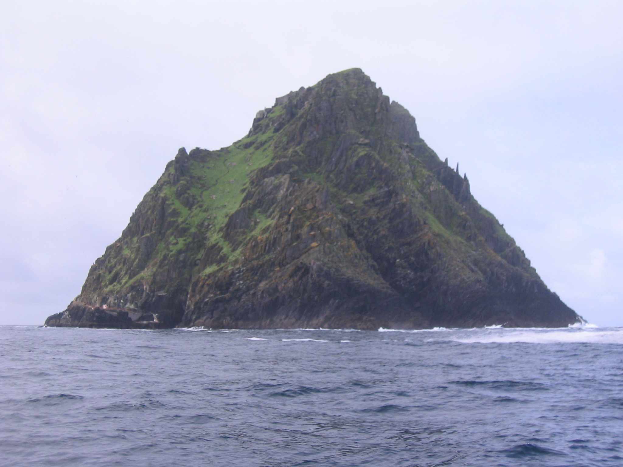
Skellig Michael (from Sceilig Mhichíl in the Irish language, meaning Michael's rock), also known as Great Skellig, is a steep rocky island in the Atlantic Ocean about 9 miles (15 kilometres) from the coast of County Kerry, Ireland. It is the larger of the two Skellig Islands. After probably being founded in the 7th century, for 600 years the island was a centre of monastic life for Irish Christian monks. The Celtic monastery, which is situated almost at the summit of the 230-metre-high rock became a UNESCO World Heritage Site in 1996. It is one of Europe's better known but least accessible monasteries.
Since the extreme remoteness of Skellig Michael has until recently discouraged visitors, the site is exceptionally well preserved. The very spartan conditions inside the monastery illustrate the ascetic lifestyle practiced by early Irish Christians. The monks lived in stone 'beehive' huts (clochans), perched above nearly vertical cliff walls.
Features[]
This terraced monastic site was originally approached by three flights of vertiginous steps (leading from different landing places) which met at Christ's Valley, the saddle between the peaks. The modern path to the lighthouse meets the southern flight of steps. The monastery comprises six intact clocháns, two oratories, 31 early grave slabs, a monolithic cross and the 13th century church of St Michael. The dry-stone walls of the clocháns are almost 2m thick, square in plan and with circular roofs. Most have wall recesses but no windows. The two largest have projecting corbels inside and out used for securing thatch or stopping sods from slipping. The oratories have windows and the smaller one is built on an artificial platform. To the west of the steps leading up the monastic buildings are two cross-slabs with a blocked souterrain between them. In the massive wall south of the souterrain is a, probably mediaeval, latrine over a deep cleft in the rock. The outer and inner walls are continuous and form a narrow oval enclosure, in the north-east part of which is the Monk's Garden.[1]
Natural Features and Landmarks[]
Christ's Valley: Christ's Valley, alternatively known as Christ's Saddle, is a U-shaped depression rising 130 meters above sea level that bi-sects the Skellig. The distinctive saddle was formed over 200 millions years of erosion and faulting activity following the great Armorican upheaval that created the mountain range of Kerry to which the Skellig belongs. The Valley terminates in two peaks, the Southwestern peak which rises 218 meters above sea-level, and the Northwestern peak with an elevation of approximately 185 meters. The Northwestern peak is home to the ruins of the eremitic monastic community that once lived there while the remains of an Hermitage connect to the monastery is still present on the summit of the Southwestern peak.
The Needles Eye: The Needles Eye is a narrow rock chimney created by a massive fissure that cleaves the principle body of the Southwestern Peak from a protruding horizontal overhang. The rock chimney forms a “gate” marking the ascent of the Southwestern Peak of the Skellig.[2] The entrance of the chimney is located 5 meters above the roughly cut path that leads to it and is navigable only with the aid of deeply gauged toe-holds and the use of a dry-stone traverse. The traverse is 4 meters by 1 meter and exists to form a level point of access into the chimney. The chimney itself is approximately 7 meters high and the ascent is facilitated by the use of stone supports that are spaced roughly a meter apart and which transition into well-defined steps carved into the central rock formation of the chimney.[3]
The Spit: The spit is a narrow ridge approximately 3 meters long and tapering to a minimum width of .2 meters located atop the summit of the Southwestern peak of the Skellig. The ridge is situated 2 meters below the installation site of a modern iron weathervane and is the location of a large quasi-miraculous stone slab that serves as a popular pilgrimage destination. Traversing the narrow Spit and kissing the slab is the ultimate completion of a pilgrimage to the Skellig.[4] The stone slab 1 meter high and 7.6 centimeters thick is often erroneously referred to as a Celtic Cross. The slab is unadorned except for a small, barely perceptible cross that was etched into the stone by a pilgrim.[5] The true origins of slab remain unknown, although speculation posits it both as the devotional item of an early hermit who left the monastery at the Northeastern end of the Skellig to pursue a more vigorous life of isolation, and as a monument erected by early pilgrims in place of a cross or shrine.[6] The slab mysterious disappeared sometime after 1977, probably falling loose from its base which is still visible today.
The Hermitage The Hermitage, although a product of the monastic community on the Northeastern peak of the Skellig, is distinct from the eremitic monastery proper. It is an example of micro-isolation, a retreat of an extreme short from the already secluded monastery, for where else was there to go on an already isolated island but “an even higher and less accessible spot”? [7] Located on the Southwestern peak of the Skellig, the Hermitage is composed of three man-made terraces interconnected by a set of steep narrow steps. The first terrace is believed to have functioned as a garden, while the second terrace contains the foundations of a dry-stone, rectangular oratory contemporary to those found in the monastery on the opposite end of the Skellig. The second terrace also contains a leacht, a small rectangular structure of un-mortared stones that is believed to have functioned either as a burial place, or a shrine to the translated relics of a saint, and even possibly as an altar.[8] The third outer terrace is enigmatic as to its usage or role in facilitating the spiritual or pragmatic experience of the resident hermit.[9] The site contains the presumptive foundations of an stone edifice; however, the difficult climate of the southwestern summit and the incongruity of their construction in comparison to the clochán found at the monastery, reject their designation as a domicile, although they may allude to some type of shelter.[10]
History[]
Skellig Michael
An Irish commemorative coin celebrating the UNESCO Heritage Site of Skellig Michael.
The monastery on Skellig Michael survived a number of Viking raids in the 9th century, notably in 823, was later significantly expanded, with a new chapel built around the start of the second millennium. The community at Skellig Michael was apparently never large - probably about 12 monks and an abbot. Some time in the 12th century the monks abandoned the Skellig and moved to the Augustinian monastery at Ballinskelligs on the mainland.
Starting in the 16th century, Skellig Michael became a popular destination for annual pilgrimages, but had no permanent residents. In the 19th century two lighthouses were built and the Great Skellig was again inhabited, this time by a changing rota of lighthouse keepers. The second lighthouse still operates, though it was largely rebuilt during the 1960s and has been automated since the 1980s. In 1986 some restoration work was done and an official tourist bureau associated with the island was established.[11] However restrictions have recently been imposed on tourist access, in the belief that tourist numbers (in particular use of the ancient stone steps up the rock) were causing a worrying degree of damage to the site. Alternative methods that would preserve the site while allowing public access are being considered.
On Monday, 30 July 2007, long-distance swimmer Robert Bohane from Ballinhassig in County Cork became the first recorded person to ever swim from Skellig Michael to the mainland.[12] The swim began at 09:07 and ended 6 hours and 29 minutes later when Robert landed at the slip in Portmagee to approximately 200 family, friends and supporters. The swim was 11.6 miles (18.7 kms) in length.
At least two visitors have died in accidents on the steep descent from the rock.[13]
Nature reserve[]

Christ's Saddle pathway
Along with its smaller neighbour, Little Skellig, Great Skellig is an important nature reserve. Between them the Skelligs hold nationally important populations of a number of seabirds, including Gannet, Fulmar, Kittiwake, Razorbill, Common Guillemot and Atlantic Puffin. Storm Petrels and Manx Shearwaters also nest in large numbers.
Conservation controversy[]
At the 2008 meeting of the UNESCO World Heritage Committee, the Office of Public Works, the Irish agency that manages Skellig Michael, came under criticism for its policies concerning the reconstruction (anastylosis) of ruins there. Critics argued that insufficient scholarly investigation and documentation of the sites had been carried out prior to reconstruction, and that insufficient effort was made to distinguish rebuilt contemporary elements from the historic fabric.[14]
See also[]
- List of abbeys and priories in Ireland (County Kerry)
- The popular children's book Skellig by David Almond features a boy named Michael.
- Loreena McKennitt's song Skellig relates the dying words of a monk from this monastery.
- Christian monasticism
- Hermits
References[]
- ↑ Weir, A (1980). Early Ireland. A Field Guide. Belfast: Blackstaff Press. p. 164.
- ↑ Horn, Walter, Jenny White Marshall, and Grellan D. Rourke (1990). The Forgotten Hermitage of Skellig Michael. Berkeley: University of California Press. p. 29-31.
- ↑ Horn, Walter, Jenny White Marshall, and Grellan D. Rourke (1990). The Forgotten Hermitage of Skellig Michael. Berkeley: University of California Press. p. 29-31.
- ↑ Horn, Walter, Jenny White Marshall, and Grellan D. Rourke (1990). The Forgotten Hermitage of Skellig Michael. Berkeley: University of California Press. p. 45-46.
- ↑ Horn, Walter, Jenny White Marshall, and Grellan D. Rourke (1990). The Forgotten Hermitage of Skellig Michael. Berkeley: University of California Press. p. 45-46.
- ↑ Horn, Walter, Jenny White Marshall, and Grellan D. Rourke (1990). The Forgotten Hermitage of Skellig Michael. Berkeley: University of California Press. p. 45-46.
- ↑ Horn, Walter, Jenny White Marshall, and Grellan D. Rourke (1990). The Forgotten Hermitage of Skellig Michael. Berkeley: University of California Press. p. 72.
- ↑ Horn, Walter, Jenny White Marshall, and Grellan D. Rourke (1990). The Forgotten Hermitage of Skellig Michael. Berkeley: University of California Press. p. 42-45.
- ↑ Horn, Walter, Jenny White Marshall, and Grellan D. Rourke (1990). The Forgotten Hermitage of Skellig Michael. Berkeley: University of California Press. p. 42-45.
- ↑ Horn, Walter, Jenny White Marshall, and Grellan D. Rourke (1990). The Forgotten Hermitage of Skellig Michael. Berkeley: University of California Press. p. 42-45.
- ↑ 2006 comment on restoration
- ↑ Reference to Robert being the first to complete the swim.
- ↑ Woman dies on Skellig Michael - The Irish Times - Sun, Sep 20, 2009
- ↑ "An Irish Riddle Wrapped in a Mystery," The Economist, 10 September 2009, http://www.economist.com/books/displaystory.cfm?story_id=14401046, accessed 14 November 2009
External links[]
- World Heritage web page
- The Forgotten Hermitage - very thorough website
- Skellig Monastery photos
- A 1994 reappraisal - in French - of the island's dry stone vestiges
| ||||||||
Coordinates: 51°46′N 10°32′W / 51.767°N 10.533°W
ca:Skellig Michael cs:Skellig Michael ga:Sceilig Mhichíl hu:Skellig Michael ja:スケリッグ・マイケル no:Skellig Michael nn:Skellig Michael pt:Skellig Michael ru:Скеллиг-Майкл sk:Skellig Michael sh:Skellig Michael fi:Skellig Michael sv:Skellig Michael vi:Skellig Michael zh:斯凯利格·迈克尔岛